When I came to Portland in 1971 I lived for a while in a ramshackle neighborhood in SE Portland, less than a half mile from the Willamette River. But there was no way to get to the river. Across the river was downtown Portland, where a freeway and a seawall also blocked river access.
Driving north along the river from my house I was most puzzled by a road sign in North Portland for Swan Island and another one across the river in NW Portland for Guilds Lake, because there was no evidence of either an island or a lake. I later learned that many years before, the main river channel along Swan Island’s east side was filled with spoils from dredging the west channel to make that shallow narrow stretch of river a navigation channel. Some of that dredging debris was also used to fill Guilds Lake, which eventually became an industrial site.
Bob Sallinger: The Willamette River was once this braided channel. It was very shallow and it had a huge flood plain that is now developed and covered with buildings and streets and industry.
Michael Pouncil: If you look at the river long enough you can see that it has its own story to tell. You can let yourself imagine how the river was a braided river. There were areas that you could actually walk through to get to the other side.
Sarah Taylor: There’s different bars and islands and lakes and wetlands. It’s just kind of this magical landscape and it was like that for thousands of years.
You’re listening to ONCE A BRAIDED RIVER: A tale of how Portland abused and degraded the river that runs through it.
Travis Williams: Right where we’re sitting you can almost imagine what this place must have looked like with this amazingly beautiful forest,
We’re sitting with Travis Williams, executive director of Willamette Riverkeeper, along the industrialized North Reach of the Willamette River, just a few miles from its confluence with the Columbia River.
TW: flood plain, wetland areas, tidal flats all along the west side of the river here and a big dugout canoe perhaps traveling up to what we now call Oregon City at Willamette Falls there. Meeting peoples that shared this area with them, Clackamas or Kalapuyan at the Falls and Chinook and other peoples further down river here.
Elijah Cetas: Where we’re sitting right now actually is a Chinook village site.
We’re in Cathedral Park under the St. Johns Bridge in North Portland, with Elijah Cetas, a member of Portland’s Sunrise Movement and a founding member of the Braided River Campaign.
EC: Across the river, those are a series of lakes and they were a really important food gathering place.
Bob Sallinger: This would have been a biodiversity hotspot and the amount of wildlife here historically was phenomenal.
Bob Sallinger is the Conservation Director for Portland Audubon.
BS: When Lewis and Clark came through here they camped on what we now call West Hayden Island and they talked about the noise from the waterfowl being so loud that they couldn’t sleep at night. But it speaks to the fact that there was incredible amounts of wildlife here and for a lot of wildlife they still have to pass through. This is a migratory corridor for birds, the fish have no other choice but to come through Portland Harbor on their life cycle.
MP: People came out this way to make fortunes in the nineteenth century.
Michael Pouncil is a member of the Portland Harbor Community Advisory Group and the Braided River Campaign.
MP: Folks from the Northeast, Boston men is what a lot of the Native Americans called them, came here to seek their dream. It’s kind of unfortunate that they didn’t really value what was already here, almost like they had coins on their eyes and were just blind to the riches that were already here.
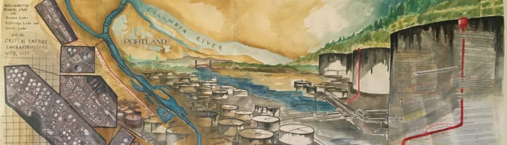
ST: There were three lakes on the west side. There was Guilds Lake, which was like around 350 acres, Kittredge and Doan Lake.
Sarah Taylor is a midwife, retired educator and a founder of the Braided River Campaign.
ST: By dredging the river and filling the lakes, filling the land so that there is no more island, we’ve really tried to redraw the lower Willamette River so that it is not braided. We tried to take every braid out of it.
BS: These river confluence areas are incredibly important areas for biodiversity. They’re also the places that we have chosen typically to develop cities because they create great transportation corridors. And so what we’ve done to our river over the last century, century and a half, is deepen it, channelized it, steepened and hardened its banks and removed all its vegetation, filled its floodplains and developed right up to its edge.
ST: Totally changing the river has cost Portland a lot of money. You still pay through federal taxes for ongoing dredging. You’re paying for the Superfund cleanup. You’re paying for all these things to keep that system of the braided river at bay. If they stopped dredging, it will go back.
BS: Today Willamette River, Columbia River, the urban stretches are in terrible shape. They’re also highly polluted. Decades of industrial pollution has created a situation where the last ten miles of the Willamette River are a federal Superfund site.
Cassie Cohen: A Superfund site means that it’s part of this federal program that identifies the most toxic sites across the country.
Cassie Cohen is the executive director of Portland Harbor Community Coalition.
CC: and requires polluters to pay to clean them up.
Rose Longoria: You have over 150 responsible parties. You have contamination that is going from one area through another area to the river.
Rose Longoria is the Yakama Nation’s regional manager for Superfund Projects in the Pacific Northwest.
RL: Because of the way it was set up, how many agencies there are, how many tribal governments who have an interest in this site, there’s just so many people at the table that it causes delays, it causes complications, it causes complexity.
BS: This is the North Reach of the Willamette which is also called Portland Harbor. This is in fact the most degraded stretch of river in the entire state of Oregon.
RL: For decades industry utilized the Willamette River as its dumping ground. One EPA official described it as an unconfined disposal area.
TW: There’s actually over 100 different potentially responsible parties along the river here, from the Port of Portland to entities like Chevron, to the folks that own this site across the way, Arkema, to Siltronic downstream of the railroad bridge where they make silicon wafers. But all of them share liability and it doesn’t matter whether you were the original owner of the site or you actually caused the pollution. If you own the site today you have liability.
RL: There are actually several liable parties that we were able to get along with and work with. There are several that, in my opinion, it seemed like whatever road block they could put in our way, they were happy to do so.
CC: It really should only take four years to do the study to figure out kind of what’s the extent of the contamination, what’s the extent of the problem, and the harms and the risks for you know, the environment and humans. But it took sixteen years for them to finalize the initial research.
RL: I personally think that you have a lot of industry who learned what loopholes there might be, how to game the system.
CC: This site is so politicized because of how much lobbying has happened, and also how much the community is organized here.
RL: Yakama Nation Tribal Government as a whole, their goal is that the cleanup that is supposed to occur at Portland will result in fish that is clean and healthy and safe to eat. And I think there’s a big push from industry to try and leave as much of the contamination as they can and not do as much active remediation as the Yakama Nation would like to see and we think is important for the cleanup of this site.
BS: We literally used the river as a dump for garbage. For decades and decades our sewers flowed into our river when we had rain event. We’ve allowed industry to pollute indiscriminately for decades. Portland thinks of itself as this great green city. We have a ten mile, eleven mile long Superfund site running through the heart of our city. You can’t be green and have a Superfund site of that size in the middle of your city.
TW: Where we are now is a stretch of the Willamette River which has been highly industrialized over the last probably 160 years. We are sitting on the shoreline of McCormack & Baxter, formerly one of the most highly polluted sites in this entire stretch of river. Back in the day that contamination went down 80 feet into the river sediments.
RL: McCormack & Baxter was an orphan site and I think the people who were responsible for that got away pretty much scot free and left the cleanup to taxpayers to clean up that site.
TW: So what they chose to do here was cap it, which means putting clean material over dirty material in a variety of layers in order to hold it in place. Over the long term it’s something that will always have to be monitored by the EPA and DEQ. [Sound of osprey] Oh, look at that osprey right there.
BS: A lot of the damage occurred before some of our big environmental laws came into effect but a lot of it’s happened since that time too. And this river is contaminated with PCBs, heavy metals, with PAHs, Dieldrin and DDT, a whole range of chemicals that have found their way into the river from industrial activities. It’s taken 20 years to get to the point where we have a cleanup plan and we’re starting to move towards implementation. That’s in large part because a lot of these businesses have stalled and delayed and obfuscated and tried to put off their responsibilities. But we’re slowly moving through this process and we hope that we’ll start to see real cleanup in this river in the next couple of years.
RL: It would be extraordinarily sad for us to think that having that kind of contamination is acceptable and should be expected if you have industry. I hope that we’re moving away from those ideals and that we’re understanding that we’re not disconnected from that web of life and anything that we do that impacts that web of life – it may not happen immediately but it will eventually impact all of us.
EC: We’ve given free license to these industries to house their dangerous infrastructure here, to leave tanks empty and uncleaned or pack up when they’re done because this place has been deemed a sacrifice zone in the past.
ST: Where you pick one neighborhood to put all your pollution, that was their urban planning philosophy and they haven’t quite given it up.
MP: Those areas are where working class folks of all races and nationalities live. We’re taking all the risk and we get none of the benefit.
ST: They would have said that there was no people here, no history, it didn’t really matter, but of course there’s Forest Park that’s in danger and the Columbia River and the Willamette River, not to mention all the people that they tried to pretend that don’t live here. The LNG tank, the tank farms are all in within a mile of tens of thousands of people.
MP: You know, I live in North Portland and what I don’t want to see and what my community has told me that they don’t want to see is all of Portland’s dirtiness you know to be in our community.
John Wasiutynksi: As you’re traveling north toward St. Helens on the Highway 30
John Wasiutynski is the Director of Sustainability for Multnomah County.
JohnW: You’re looking to your left and you’re seeing this beautiful bucolic old growth forest, Forest Park, which happens to be the largest urban forest reserve in the entire country .
MP: And you look to the right and it’s doom. You see petroleum industry infrastructure; you see a lot of risk.
Jay Wilson: The Critical Energy Infrastructure Hub, the CEI Hub, you know makes an impression when you first visit Portland around that area by the St. Johns Bridge.
Jay Wilson has worked as an emergency manager for over 20 years and is the former chairman of the Oregon Seismic Safety Policy Advisory Commission.
JayW: It just looked like those tanks and the tank farms kind of went on forever.
EC: It’s a huge, huge sort of amassing of explosive, of toxic fuels and chemicals and it’s kind of remarkable because you see these white pillars running for six miles right all the way to the edge of downtown Portland.
JohnW: Most of them are housing gas or diesel but there’s also like waste oils, there’s LNG, there’s diesel fuel and other nasty chemicals that are not good for people or the planet but are obviously in use throughout our economy.
MP: The Willamette River was dug out 40 feet deep by the Corps of Engineers in order to make it navigable. The tank farms, the railroad tracks, Highway 30 is built on that sediment that was pulled out of the river.
JayW: All that artificially made land from non-engineered fill, that’s some of the worst possible land to build on when it comes to earthquakes.
MP: It’s a loose soil. It’s very susceptible to liquifaction. When you think about the possibilities of an earthquake happening there or even just an accident, a fire, brings about a lot of risk. 90% of the fuel for the whole state is in that area.
JohnW: What you don’t see from the roadway are two really important parts of this system. One is a pipeline that comes all the way down from Anacortes and Cherry Point where there’s all those refineries up in Washington, and puts fuel inside the storage tanks, and old rickety seawalls that are holding back soil where these tanks are located, in addition to these docks and pipes that come out into the water to either bring fuel off of a barge onto land or vice versa.
JayW: There’s pipelines everywhere running around connecting all of those things and managing a host of different substances. I mean it’s not just crude oil or gasoline, it’s all kinds of additives. All of those are places that can rupture and break and spill and leak and release things into the soil and water.
Jack Kerfoot: There was a horrendous fuel tank fire in 1911 in central east Portland.
Jack Kerfoot is a scientist, author and board member for Engineers for a Sustainable Future.
JK: The mayor and the city council mandated that all fuel tank storage facilities be outside the city. Well, those fuel terminals then moved to town of Linnton. Well in 1915, the city of Portland annexed the town of Linnton and we started to see a growing number of fuel storage facilities.
ST: I live next to Forest Park in the Linnton neighborhood.
Sarah Taylor, with the Braided River Campaign
ST: I live in a pretty nice wild place, as a lot of people do. We live kind of up in the hills. But all we have to do is drive down our hill and we can pretend it’s not there, as I did for a long time, or we can acknowledge that we also live on a fault line, the Portland Fault Line and then down on the river we have all the tanks.
Shawn Looney: Looking out my window right now I see a blue fog of diesel exhaust that is coming from the trains. There are train tracks right fairly close below us.
Shawn Looney is a longtime resident of Linnton.
SL: A lot of times there are one or two oil tank cars, sometimes it is an entire train of tank cars. We have thousands and thousands of gallons of explosives going through our community .
ST: So we’re just off Front Avenue. So picture Front Avenue in downtown Portland and on one end it’s million dollar condos. Now here we are on the other end of Front Avenue, it’s a dirt road. Right in front of us is Kinder Morgan tanks built a long time ago. Some of them are like 1930, some are 1950. I asked the EPA the last time they were inspected. I think they said 1970.
When you drive through Linnton it appears that half the town is missing, which in fact it is. Until the 1960s Linnton lined both sides of Highway 30, but when the city of Portland and the Oregon Department of Transportation decided to widen that road, they bulldozed the entire west side of the town.
SL: Before Highway 30 was widened, Linnton had everything a community could ask for. All of those things are gone. It’s a skeleton of what it used to be now.
ST: When they made the highway, they promised that this would be the downtown that they tore down. And Kinder Morgan and the Working Waterfront just opposed it. We have Forest Park, the fault line, the Olympic Pipeline, the gas pipeline and oil trains and that’s how we roll here. So here we are, we’re on the river. We can see the beach and this always was part of Linnton and they’ve just systematically taken it away. You can kind of peek down and see that it would be a perfectly nice beach for people. Before they made it hard for people to go down here, you could see where Kinder Morgan was leaking oil into the river but now nobody can really easily go down there and check.
TW: At present there is no public access to the river in Linnton.
Travis Williams with Willamette Riverkeeper
TW: It is closed in by private property or industrial property. You look at the homes there in Linnton that used to be there and there’s still a few left and they’re a great example of just how an area can transform over time to the point where you’ve moved most of the residents of an entire street that back then lived upon an area that was much less industrialized but today is highly industrialized.
SL: The head of the bureau of emergency services said, I lose sleep about you folks in Linnton. When you have an earthquake, you are all going to be very, very vulnerable. I’d like to see the city buy up all the homes in Linnton and just have it be an industrial complex. A lot of us were really outraged that she would suggest that we should all for our own safety leave Linnton and just let it be an industrial complex.
JohnW: What I would say about Linnton is that the people who live there now are really the strongest advocates for addressing the threat of the CEI Hub.
John Wasiutynski, Director of Sustainability for Multnomah County
JohnW: Besides their activism to try to get the city, the county, the state to take more action, they’re also taking action to prepare and get themselves ready as best they can to respond and protect each other in the event of a disaster.
When the tank farms in the CEI Hub were built no one was thinking about earthquakes. But since the late 1980s scientists have been warning about the inevitable danger posed by the Cascadia Subduction Zone, a fault line which runs along the Pacific Coast from Northern California to Vancouver Island. And now we know that there is a one in three chance of a 9.0 earthquake rupturing the region in the next 50 years. To make matters worse there is also a fault line running right underneath the CEI hub.
JohnW: When an earthquake occurs the soils at the hub will begin to act more like a liquid as opposed to a solid.
JayW: The ground there is both prone to liquifaction, which is where it can’t bear any weight during an earthquake, but that type of soil also when it hits soft soils can actually multiply the intensity of the ground shaking.
JohnW: And when that happens these tanks will start to move. The connection points between the tanks and the pipes that connect to the pipes will break. The tanks themselves will begin to buckle. Some of the tanks, especially if they have gasoline in them have floating tops so as the tank rips open, the floating top will start to crash down. Then you’ll have metal on metal contacts so there’ll be sparking, so there can be explosions or fires that will occur. In addition to liquifying, soils will spread. The soil will move toward the river, so tanks that are closer to the river will actually spill their contents into the river.
JayW: If you’ve got many facilities that are catastrophically failing on top of each other, the earthquake would just compound the problems of everything. We have to expect that is going to happen.
JohnW: Hundreds of millions of gallons of fuel are stored at the tank farm. The volume is estimated to be larger than the Deep Water Horizon, which is you know to date been the largest oil spill in US history. But rather than occurring over a number of weeks out in the middle of the Gulf of Mexico, this is happening in a matter of minutes in the middle of a major American city.
JK: If you have unrefined oils, gasoline and diesel, or heating oil, if that gets into the river, you would expect to see all the marine life killed down to the Pacific Ocean, contamination in the ground water, contamination and devastation of the farms on Sauvie Island.
JohnW: The impacts will ripple out from that center of devastation because there’ll be a smoke plume presumably of this toxic big black blowing smoke that will spread over miles.
JayW: By 2019 I started making phone calls and found from talking to all these spill managers, to the EPA, to NOAA, does anyone know if there’s an assessment of what this could all look like, and the answer I got from about a dozen people was, no, there was no contingency for this. Every facility has an emergency plan for its own problems but not cascading failures from an earthquake.
JohnW: Post earthquake there’ll be rubble and devastation, not just here in Portland but throughout the entire region. Fuel to power things like bulldozers and fire trucks is going to be severely limited. There’s all these multiplying consequences of this single point of failure.
JayW: I started just doing the math of this report that had just come out by the city of Portland and Portland State University, saying there’s about 300 tanks and approximately 300 million gallons in storage. If we lost 3% of that, that’s about 10 million gallons. That’s equivalent to the Exxon-Valdez. And that was shocking to me to think, well there’s no way that only 3% would leak if these things start rupturing. That was my call to action to say, we need to do something about it.
SL: We have 300 million gallons of flammable fuels right in the midst of our river that is a superfund site and we want to clean up, but the minute we have an earthquake, the millions and millions of dollars that we may pay to clean up the Willamette River will be for nothing. Because we will have fuel. Some of it will sink to the bottom of the river, some of it will float to the ocean and pollute everything in its wake. Why haven’t we woken up to the extreme danger?
Multnomah County and the City of Portland have taken initial steps to deal with this impending disaster. In February 2022 they released a report “Impacts of Fuel Releases from the CEI Hub” which graphically details just how devastating and expensive the earthquake damage will be. At the same time the Oregon Legislature passed a bill requiring the tank farm owners to assess the vulnerability of their storage tanks in case of a major earthquake and what they will do to reduce the risks. The bill also requires the Oregon Department of Energy to come up with a security plan to prepare for an earthquake, protect communities and align with Oregon’s efforts to reduce greenhouse gases by 90% by 2050.
JayW: The emphasis is still on trying to band-aid together these fifty to one hundred year old structures that were never built with earthquake design criteria at all. Only the 2004 and later designs up there are even close to what we need to have them built to. The impact to the salmon stronghold that we’re working so hard on in the Columbia Basin and then of course, what does all of that mean to the tribes?
BS: The tribes are very heavily involved, for example, in the Superfund process and the natural resources damage recovery process because this is still and incredibly important area to them as well.
Bob Sallinger, Portland Audubon
BS: That needs to be factored in at a foundational level as to how this landscape is repaired and redeveloped.
RL: The Willamette River was an area where the tribe went to trade, gather and continues that to today. There’s a multitude of different species and plants and medicines that the tribe would have traveled to go and gather.
Rose Longoria with the Yakama Nation
RL: If you’re going to an area to collect resources that are important to not only your way of life but your traditions and your diet, you want to make sure that what you’re collecting is also safe for you to collect and eat. When Yakama thinks about the Willamette, they want to do their best to try and protect those resources as best they can.
[Music bed for Station break]
You’re listening to Once a Braided River, a tale of how Portland abused and degraded the river that runs through it.
BS: We have treated it as a sacrifice zone and we’ve codified that in a wide number of ways that make it very, very hard to penetrate and make change. One of those is by declaring industrial sanctuary areas.
Tom Armstrong: We want to preserve our industrial land base and we want to protect it from uses that may conflict with those industrial uses. So we don’t want to see a lot of new housing being built there because we get a lot of complaints.
Tom Armstrong is a supervising planner at Portland’s Bureau of Planning and Sustainability.
TA: As the Pearl District turned over from what was a rail yard and an industrial business, as people moved in, there would be complaints about the auto shop next door and the smells from the pet food manufacturing plant. So the industrial sanctuary concept was, this area is going to be for industry. We have restricted what kinds of uses can take place in these industrial areas as a way of preserving that industrial capacity.
BS: There’s some legitimate drivers for that. Some of the big box stores were trying to move into that area and they were displacing industry and also creating much more low paying transitory jobs. Another thing that drove it was industry itself transitioning its land because when you up zone you can make more money. They were up zoning in a way that lost jobs and also created a demand to create new industrial land for the land they transitioned.
TA: It’s not just about business vs. the environment but it’s also about economic opportunity and who has access to a good quality job in Portland.
BS: So there were some reasons for it but a lot of it was simply to protect industrial interests and to ensure that other concerns, other community priorities would not be integrated effectively.
TA: We’re still trying to balance the policy outcomes with respect to the natural resources of the river. We began you know, as planners in the 80s, to take a closer look at the river and what the resources were. I think the importance of the river in terms of water quality and habitat really got a boost when the salmon runs were listed as endangered species.
TW: There’s a few nodes of green as you go up this stretch of river. There are little sections of it that harken back to what the river was, with the sandy beach and some native plants along the shoreline. But those are few and far between. We’re looking across the river right now to a site called Arkema and the whole bank there has been, you know, artificially graded. It’s all built on fill. There’s a bunch of Himalayan blackberries on that riverside stretch and then the upland is highly contaminated and that’s a site we can look over now and nothing is happening.
BS: A decade ago the city and the community spent a huge amount of time developing the North Reach River Plan, which is a future vision that did integrate multiple needs on the river. It did pass but all the river industry and the Port of Portland went down to Salem and under Goal 9 challenged it and so after all this work and all this community input and adoption, the Port and others were able to get it thrown out and it’s never been updated as a result. It was that demand for industrial land that drove the battles over West Hayden Island, an 800 acre natural area. It represents 4% of the remaining cottonwood and ash bottomland forests on the lower Columbia and the Port basically wanted to pave it over and put in marine terminals. Although we have this alleged great deficit of industrial land they could never say what they actually needed to build there. They were successfully opposed with a coalition of Audubon, the Yakama nation, and the manufactured home community at Janzen Beach. Up until that point, industry and the Port had been monolithic in their assertion that they needed more river industrial land. I think we have a new generation coming in and looking at things differently, and for the first time we have a really big player on the river saying, times have changed. And so we’re now working hand in hand with the Port to convert West Hayden Island into a natural area.
In response to several massive fossil fuel projects that were being proposed for the Portland area, Portland City Council developed new zoning laws that would prevent the construction or expansion of any new bulk fossil fuel infrastructure.
Jan Zuckerman: In December of 2016 the No New Fossil Fuel Infrastructure ban was unanimously passed by our commissioners.
Jan Zuckerman is a retired teacher and activist
JZ: I remember just celebrating. We just couldn’t believe it. We just, we walked out of there just feeling like everything’s going to shift. We’re going to start to maybe transition away from fossil fuels on our river. If these industries can’t expand, maybe just won’t want to be here.
Erin Saylor: Unfortunately industry immediately went to LUBA, which is the Land Use Board of Appeals.
Erin Saylor is a former Columbia Riverkeeper staff attorney
ES: The Land Use Board of Appeals upheld the idea that the city could pass a zoning ordinance like that, but required the city to provide more findings and more support for why it was necessary under the 2035 Comprehensive Plan.
Eric de Place: Portland has taken the most assertive approach to trying to ban large scale fossil fuel storage infrastructure.
Eric de Place is a fellow with Sightline Institute in Seattle
EdeP: But there are some exemptions and some loopholes that have created real problems.
ES: The city’s starting to try to change the way its zoning code is written but of course once you make those changes you still have all these existing facilities and so, you can’t really go back and apply new laws and new requirements to existing facilities.
EdeP: The electorate is supportive of banning fossil fuels but it’s not clear how exactly even in a place as progressive as Portland we can actually steer government and land use law and the rest of it in a way that accomplishes our ends. There’s a lot of attention now on Zenith out in the Northwest part of Portland where there’s an existing facility that is now capable of sort transforming itself and possibly enlarging into a different kind of facility. And it’s extremely difficult to figure out how we use the power of land use code and zoning and all the related regulatory tools in that tool box to make this stuff go away.
ES: Zenith Energy Terminal Holdings is a oil by rail facility that’s located in the CEI Hub. The facility was originally constructed right after the war in 1947 as an asphalt refinery. Over the years it’s changed hands a number of times and was used for storage of crude oil and petroleum products. Arc Logistics came in and started operating as a petroleum storage facility. Then Zenith purchased Arc Logistics towards the end of 2017 and almost immediately set to work building new rail unloading platforms.
JZ: People in the community started noticing that there were these trains coming in. But I kind of felt like the ban passed and so we were going to see what happened with that. But they just kept coming.
ES: Arc Logistics did get a building permit from the city of Portland to build three new rail unloading racks. When Zenith took over the facility they immediately started construction using those existing permits.
JZ: So here we have this no new fossil fuel infrastructure ban. Zenith was getting away with offloading all this oil and we started to see that it was tar sands coming from Canada. So we planned an action to stop the trains.
Chanting: No more Zenith, no more oil. Keep your carbon in the soil.
JZ: Very early in the morning folks built a small house, had a dump truck deliver a bunch of soil and we brought in plants and we planted a garden and plopped our tiny house next to the railroad tracks. We coordinated with some other groups to have a big rally there. We spent the night there and the next day we were arrested.
More chanting: We don’t want no Zenith here. Say it loud, say it clear, we don’t want no Zenith here.
JZ: Some of us repeated that action and we went once again and put the tiny house down and planted a garden and got arrested a lot quicker this time. The whole point was to stop these trains and then to let Zenith know that they’re not going to just keep getting away with this.
Chanting: Say it loud, say it clear, we don’t want no Zenith here. Say it loud, say it clear, we don’t want no Zenith here.
JZ: We organized a lot of community forums where we brought in community members to talk about what was going on. We had at least five forums around the city and then we pushed the city to having a big one, where a lot of people came.
Jo Ann Hardesty: I want to thank you because you have been engaged in this issue for quite some time and I love that you are pushing us to think bolder and braver than we believe we can.
[Applause and cheers]
Portland City Commissioner Jo Ann Hardesty welcomes the public to the city’s Zenith Community Forum in July 2019.
JH: I know that the city of Portland’s been working hard to try to figure out how we can legally make sure that the limits that we place around this industry are legally defendable and that we as a community will get what we want, which is to ensure that we are clear that what we’re about is green energy and not dirty energy.
Moderator: Next: Audubon Society, Bob Sallinger
BS: This community is tired of industries that come in here and pollute and put our communities at risk. It’s time for that to stop [cheers]. The Zenith facility will quadruple the number of oil trains coming into that facility. One quarter of all the residents of Portland will be in the blast zone of these oil trains as they pass through. And this oil is coming from the Tar Sands, one of the most polluted places on the planet. This facility will put our community at unacceptable risk, it will put our environment at unacceptable risk. To Zenith, we understand you have a representative in the room here tonight. You owe it to this community to stand up and face the community. You owe it to us to tell us how you are going to keep our community and our environment safe and I suspect that you’re not willing to do it because you know that you can’t.
Besides the building permits that Zenith inherited there was another permit that became pivotal in the effort to stop Zenith. Zenith was operating under an expired Clean Air permit from the Oregon Department of Environmental Quality, which Columbia Riverkeeper challenged. They succeeded in getting DEQ to require that Zenith apply for a new clean air permit, and before DEQ could grant this permit that they needed to get a land use compatibility statement from the city of Portland, certifying that Zenith’s operations complied with Portland’s comprehensive plan and zoning ordinances. If the city denied the land use compatibility statement then DEQ could not grant the permit.
JZ: In the past from my understanding of Land Use Compatibility Statements, they are just a check off box. The city just is like oh yeah, that works with the comprehensive plan, that’s nyab, nyab, nyab.
ES: Once Oregon DEQ did tell Zenith that a new land use compatibility statement or LUCS for short, was required, then we shifted our advocacy efforts towards the city to deny the land use compatibility statement.
Erin Saylor, Columbia Riverkeeper.
ES: So this has been a really big opportunity for the city and local activists to really finally squash this kind of unfettered expansion that Zenith has been doing.
JZ: With all of the ongoing pressure of many community members weighing in on this and pushing the city, they denied it, based on climate and the fact that the amount of trains that they are bringing in is an expansion.
ES: Oregon DEQ sent Zenith a letter and said, okay, since you don’t have the land use compatibility statement we are going to deny your air permit, which would have taken effect within 60 days of that letter, had Zenith not requested a contested case, which is what they did. Now that Zenith has requested a contested case, the permit is once again administratively extended for as long as it takes to wrap up that contested case process. Basically that means that Zenith is right where it’s always been.
JZ: When people started zooming on Zenith, and they’re down there, they realize, oh there’s Chevron there, oh and guess what, NW Natural is there and there’s a lot of other bulk fuels there, and that’s where the Olympic Pipeline comes in. And people are starting to widen their view because of Zenith and realizing we’re going to have more Zeniths. This is going to keep happening if we don’t do something to change the way we zone, the way we plan our river.
In the spring of 2021 the Braided River Campaign held a kick off rally and press conference at vacant Terminal 2 to announce their vision of a green working waterfront here at the Portland Harbor.
Sarah Taylor: Hi, everyone. My name’s Sarah and I’m here because I believe that we can have a new vision for this stretch of harbor. I’m asking you that here, to join me in imagining what that could be. This stretch of land is indeed called a sacrifice zone. When you turn on your gas stove, that gas is stored in North Portland. When you fill your car with gas, that’s coming from North Portland. Right now we have miles of fossil fuel trains parked next to a daycare center in Linnton. I want a new vision for a very wounded piece of land. We can, years from now, look back and we will say, yes, when I was young this was full of tanks. The river was polluted. And people will say, it’s so nice now. People are fishing, it’s beautiful. But to do that we are going to ask the city of Portland, the state of Oregon, Multnomah County and the Port of Portland, to come together and declare this a green working waterfront and make every piece of planning, every decision, reflect that deep, deep commitment to our future.
JZ: Sarah lives in Linnton so for years she’s been saying we’ve got to do something about the fossil fuel industry here.
Jan Zuckerman, Braided River Campaign
JZ: She would come to the Stop Zenith Coalition meetings waving her hands saying, come to the river. And Sarah sent out an email and said, let’s see about getting a billboard maybe on Highway 30 or somewhere there that could look at what the river once looked like and could look like, and said, do folks want to meet.
EC: The first meeting we had, when we just came together and, as a group of climate activists and river advocates, and we were talking about what our group could be called and one of our members said, you know, I’ve always loved this idea of that the river used be braided.
Elijah Cetas, Braided River Campaign
EC: I think there’s something about this image of a braided river that helped us as a group come to think about what we’re trying to do together. It speaks to the past to what the river was and could still be and the way it wants to flow in its channel. And I also think it speaks to the present, to the fact that we are still braided together, that Linnton is connected to St. Johns, is to connected to the rest of Portland, and to the Superfund site, to the history and to the fossil fuel economy, and to the birds that fly down the Pacific Flyway. Our goal is to weave together these intersectional and distinct issues that we hear our community talk about and that we think about, that aren’t right now reflected in the way the industrial hub is planned.
BS: As much as we’ve hardened the river and hardened its banks and hardened its flood plains, we’ve hardened the processes that allow us to make change.
Bob Sallinger, with Portland Audubon, speaking at the Braided River campaign kickoff rally.
BS: Who here has heard of the Economic Opportunities Analysis? That is the process by which we determine the future land use of this area. Every five years the city looks at its land use planning and determines whether it has enough industrial land in order to meet a state mandate that says we must have enough industrial land for the next twenty years. The city does it mostly behind closed doors with giant multinational industrial interests at the table. And each time they determine that there’s not enough industrial land and because there’s not enough industrial land, that precludes us from doing anything differently. We are here today to demand a different vision. And the way we’re going to get there is by this kind of grassroots organizing. So we’re really proud to be part of the Braided River Coalition.
EC: We figured out where we have some power in the land use planning. The city of Portland has made resolutions and ordinances to talk about climate change, but that’s not impacting the actual infrastructure of this hub.
BS: Basically every time a new environmental regulation is proposed, a restoration project is proposed, industry is standing there saying, we can’t do it because it will take away our land base. And unfortunately statewide land use planning Goal 9 actually backs them up on that, and they’ve been able to manipulate that process to have it determine that we don’t have enough industrial land and then use that determination as a way to block these efforts to recover and restore this river.
TA: Goal Nine is the economic development goal in the statewide planning system.
Tom Armstrong with the Portland Bureau of Planning and Sustainability
TA: Those rules were written a long time ago in a different political structure where business had a stronger voice in the system.
BS: The way that cities achieve meeting statewide land use planning Goal Nine is that they do an economic opportunities analysis, or an EOA. This is a process that historically is pretty esoteric. It doesn’t have an immediate impact on the landscape but it sets the foundation for what comes for years after they do it. They ask industry what they think they’re going to need over the next twenty years for industrial land development. They look at the supply of existing industrial land and then they make changes to make sure that they have enough land to meet that demand over the next twenty years. What that has allowed industry to do is to perpetually argue successfully that we have a scarcity of industrial land and that we need to find more. Despite the argument that we don’t have shovel ready large industrial sites, this site, Terminal 2, has sat vacant for years and years and years. It’s owned by the Port of Portland. It has a giant crane on it, huge open areas, warehouses, administrative buildings. It can be converted to really any sort of river dependent use that they could possibly find an occupant for. And they have simply been unable to find anybody. This isn’t unique to this terminal. They also converted Terminal 1, just up river from here, to high priced condominiums more than a decade ago. Terminal 6, their biggest terminal, has been sitting mostly vacant for the better part of half a decade. The fact is we have not been successful in luring new employers to come to this stretch of river. We’re a hundred miles from the ocean. This is a relatively small port. The ports along the Columbia River compete rather than collaborate. And as a result after years and years of arguing that we needed more industrial land, that we couldn’t afford to protect our environment, that we needed to convert open space, the Port is now proposing to convert this site into a baseball stadium, restaurants, high end condos.
ES: Our goal as the Braided River Campaign is to bring our own plan and bring our own ideas about what economic opportunity means, and to see that reflected in the city’s plans. If we can do that in this realm of power that industry has traditional held, we can enter that space and we can say, we can mix conservation and ecology with industrial lands. We can look at how much access there is to the water and we can value that as an economic opportunity. We can look at how much affordable housing there is in the surrounding area and we can say, is this serving the people who work in the industrial lands.
BS: We’re very hopeful as the city goes through a process of revising its analysis of jobs opportunities, that a more honest, realistic view of what’s happening on this river will be incorporated. We expect to see a fierce battle because there’s lots of businesses that are vested in maintaining the status quo, not stepping up to their environmental responsibilities, keeping the community out of these places, not cleaning up their contamination. They’re the wealthiest businesses in Oregon, some of them are the wealthiest businesses on the planet. We have oil companies down here and Schnitzer Steel and Gunderson Marine. It’s going to be really important to show up the next time the city does its economic opportunities analysis, which is starting right now, and weigh in and say, we care about jobs, but we want this landscape to be healthy and safe and accessible as well. We want that for the people that live here. We want it for people that depend on this river for their survival. We want it for the people that work on this landscape. We want it for the wildlife that traverses this landscape.
TA: What decisions can we make now through the EOA and what is more speculative, more visionary, more longer term? We want to figure out flood plain regulations or we want to figure out buffer zones around neighborhoods, versus, do we need fossil fuels in the year 2045 or not?
BS: This city’s done this economic opportunities analysis really largely in isolation. They come to these conclusions that then are codified essentially and then when the public gets involved either because of tree code or because of a natural area like Hayden Island, suddenly they discover that there’s all this regulatory infrastructure that prevents doing what they think ought to happen. So if we can get the EOA right, that opens up a whole array of opportunities to do other things better as well.
TA: How do we balance and navigate and look at, well, what are the impacts of increased regulation, expanded environmental zones that limit the amount of development that can take place along the riverfront.? We just need to carefully consider all of those aspects to be able to find that middle ground that optimizes the need for business close in to Portland, the need for economic opportunity for people without college degrees and that promotes and improves the resource value of the river.
JohnW: I see habitat restoration and bringing people back to the river and removing contaminated sediments and daylighting long forgotten streams,
Multnomah County Director of Sustainability, John Wasiutynski
JohnW: and doing that in partnership with tribes that called the river, this land, home from time immemorial.
Rose Longoria: Yakama Nation is here, it will always be here, and we will continue to push as we are and will continue to do at Portland Harbor, until we get to a place where the resources are protected.
TR: It certainly does seem like we’re going to have more opportunity to find sites that are either cleaned up or sites that were never that contaminated, and repurposed them for the enjoyment of people, the enjoyment of a beautiful river setting and certainly for fish and wildlife.
Travis Williams, Willamette Riverkeeper
TR: On this 11 mile plus stretch of river, really we have to return some of this to more natural habitat or we’re gonna not have a fighting chance to recover salmon that have been here for tens of thousands of years.
BS: One of our goals here is to make sure that as this landscape redevelops, the riverbanks are restored to the degree possible, that we create shallow water habitat, that we put in riparian vegetation. That’s really essential to recover salmon on the Willamette River system. Across the river you can see a strip of riparian vegetation and an area where the beach still remains. For salmon that are migrating to the ocean, juvenile salmon, what they really need is shallow water habitat along their migratory routes. That’s where they stop, rest, forage, get away from predators, get out of the main current. This is what they need to survive and what we’re seeing is one of the very few remnant pieces of habitat left on this 11, 12 mile stretch of river.
CC: When you talk to people that are in their 80s that grew up along the river, they have stories of how they would just walk around and hang out in the wetlands and be able to kind of find their way to the river and to multiple spots where they could fish.
Cassie Cohen, Portland Harbor Community Coalition
CC: Not anymore.
John W: Maybe we think about that lost westside of Linnton. Can we bring back more of Linnton and connect Linnton more into the community and wouldn’t it be great if we could see Forest Park come down through that industrial area and touch the river again.
JZ: Here we are in the middle of the CEI hub, on Front Avenue, surrounded by the tank farm, with signs that are warning us of the dangerous cargo.
Jan Zuckerman, Braided River Campaign
JZ: We need a plan from the city to dismantle these tanks. As soon as possible!
BS: It’s a peregrine falcon. There it is. Uh, look on the boom that’s coming off the side, that’s the peregrine right there. Can you seem him? That’s fantastic.
JohnW: I think one thing that Portland has a lot of is creativity. And what I’d like to see for the CEI hub area, is Portlanders to apply that creativity to imagining a different future for our community. A future that doesn’t rely on fossil fuels, a future that relies really on the most renewable resource of all, which is human ingenuity and innovation.
Once a Braided River was written, narrated and produced by Barbara Bernstein, who also composed and performed the music. Chinook traditional music was performed by Sam Robinson. Yakama traditional music was provided by Jeanne Givens. Banjo music was performed and composed by Bob Bernstein and Doc Slyter played original Coos flute music.
Special thanks to Jan Zuckerman, Sarah Taylor, Melissa Marsland, Damon Motz-Storey, Patsy Kullberg, Bonnie McKinley, Dan Serres, Julia Bonnheim and the Braided River Campaign.
This project was funded by the Regional Arts and Culture Council and Stand Up to Oil. Visit our website onceabraidedriver.org.